Crossing “the bar” is something no mariner takes lightly. At coastal communities like La Push, Washington, a prominent sand bar across the river mouth creates a dynamic marine zone called a bar.
Along the Washington and Oregon coasts, federal law establishes “Regulated Navigation Areas” (RNA) at prominent river bars. Local U.S. Coast Guard stations are charged with monitoring bar and weather conditions for each RNA and publishing condition reports. They may also place bar restrictions over part or all of an RNA to designate the minimum size recreational or uninspected commercial passenger vessel that may operate due to the conditions. (1)(2)
Several variables combine to make bars so dangerous.
Rivers

Pacific Northwest rivers carry vast amounts of water downstream from their sources high up in the mountains. With the river flow, sediment travels downstream towards the river mouth.
Encountering incoming waves and tidal action, the river flow slows near its mouth. Sediment that was once carried in suspension begins to settle out and sink towards the river bed. Over time, accumulating sand adds up, forming “the bar”.
Swells
Ocean swells can travel thousands of miles from where they were first generated by powerful wind storms. They carry enough energy to travel these great distances unsupported and eventually expend themselves onshore with tremendous force.

Located along the coast, river mouths stand vulnerable to the constant onslaught of incoming waves. Forgetting for a moment the other forces involved, this endless “parade” of incoming energy clashes with the constantly out-flowing volume of river water.
Shoaling
When swells approach shore, water depth naturally decreases. As a result of this “shoaling,” the circulating internal energy of each wave begins to collide with the sea floor. Just like river flow, ocean swells change as they slow down. As waves slow, they pack closer together and steepen; wave heights can increase significantly in the process.
When water depth reaches a critical ratio to wave height, waves reach maximum steepness and “break” dramatically as surf. When breaking, waves expend obscene amounts of energy and pose an extreme hazards to vessels of all types.
Tides
In the Pacific Northwest, there are two high tides and two low tides each day. When tidal current flows out to sea after high tide, it is said to be “ebbing;” when it returns towards shore after low tide, it is said to be “flooding.” Each current cycle lasts six hours (between the high and low tide heights), with maximum velocity about halfway between the extremes.
During the ebb current, the river’s outflow is augmented significantly by the receding tidal current. During new and full moon phases, the tidal flow is even greater and current velocities can exceed eight knots.

All of this magnifies the slowing effect that river flow has on incoming waves. Mariners know to avoid bars during the ebb, when out-flowing river and tidal current slow incoming waves significantly. At these times, wave’s will be their steepest, tallest, and most confused. In a matter of minutes, river bars can transform from inviting inlets with rolling swells, to turbulent, choppy, and unforgiving zones.
Geography
Local physical features also affect river bars. Just like light waves, ocean waves behave predictably when encountering different types of features.
As waves encounter shoaling below the surface, the wave slows where depth is the least, and the wave bends towards the shallowest area. This “refraction,” or bending process can cause waves to change direction by greater than 90 degrees. At a river entrance vessels can encounter waves from multiple directions, creating confusion and extreme hazards.
Waves also reflect off features like billiard balls on a pool table. Jetties, islands, beaches, and rocks all cause waves to reflect after expending their energy upon impact. For mariners operating near the features, reflecting waves further confuse the situation.
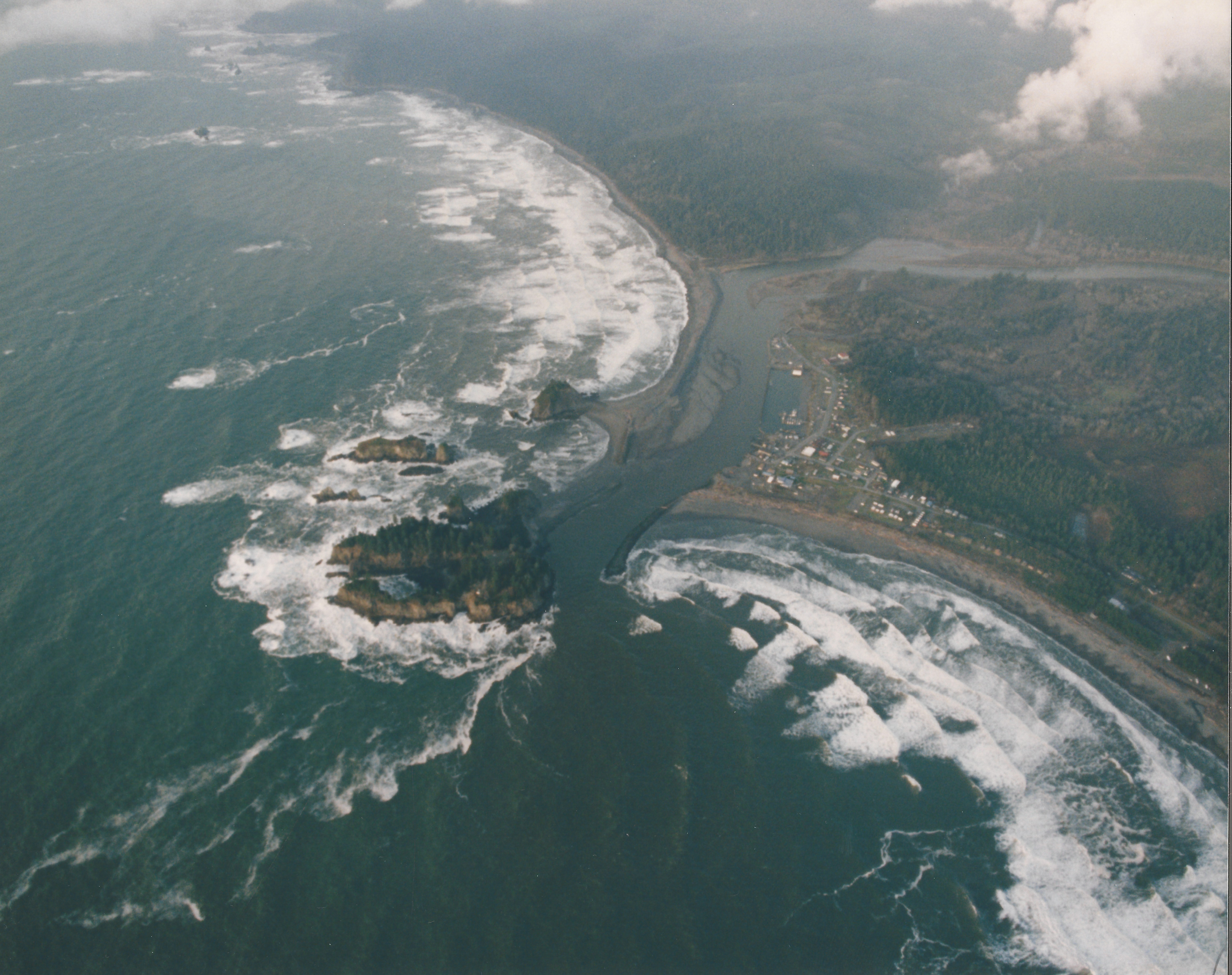
The Quillayute River Bar

Every one of these forces is present at the entrance to La Push harbor. If swells are arriving from the north, James Island can protect much of the bar area. In winter, typical swells arrive from the south or southwest, and drive waves into the southern shore of James Island. At times, this bar crossing can be extremely challenging. (3)

Local mariners transit southwest from Wash Rock towards the “Q” Entrance buoy offshore. When conditions are right, Coast Guard operators hug close to James Island because the reflective waves there can “cancel out” incoming swells.
But reflection off of James Island can also presents a unique challenge. With the right swell direction, waves impacting James Island bounce off, back towards the navigable channel.
U.S. Coast Guard video
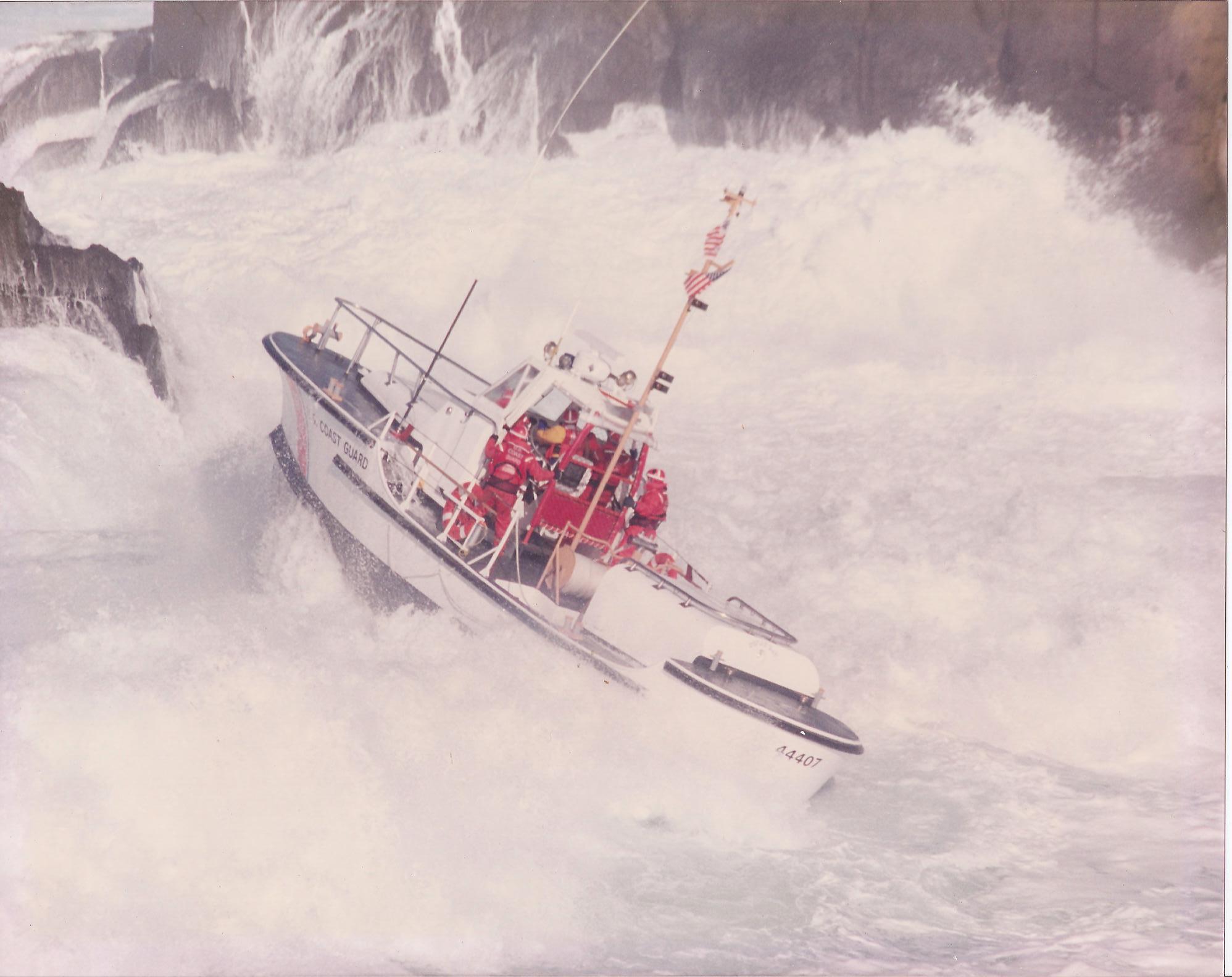
Vessels near James Island face reflected waves while also focusing on the predominant arriving swells. Trying to keep a boat’s bow pointed into reflected waves could cause an operator to navigate towards James Island. If they were close to the island in the first place, they could end up in the surf immediately adjacent to the island’s steep cliffs. Still at the mercy of the true swell approaching for seaward, they could be driven into the rocks. (5)(6)
This is likely what happened to BM2 Bosley, and what did happen to BM1 Placido. In the dark, BM2 Bosley likely followed his training to keep the motor lifeboat’s bow pointed directly “square” into the power of oncoming waves. Being close to James Island’s western end and encountering reflected waves, he would have pivoted towards the island to keep his bow aimed at the reflected waves. This alteration of course would bring him dangerously close to the island and its outlying rocks. When the true NW swell arrived, it could have “mauled” the CG 44363 from its port beam (5). During CG 44393’s bar crossing, BM1 Placido experienced the same wave dynamics, but managed to stay off the rocks. (5)(6)
Resources
(1) “Regulated Navigation Areas; Bars Along the Coasts of Oregon and Washington.” Federal Register, https://www.federalregister.gov/documents/2014/04/14/2014-08374/regulated-navigation-areas-bars-along-the-coasts-of-oregon-and-washington
(2) “Bar Camera Images.” National Weather Service, https://www.weather.gov/pqr/barcams
(3) “Waterways Management Branch.” U.S. Coast Guard 13th District, U.S. Coast Guard, www.pacificarea.uscg.mil/Our-Organization/District-13/District-Staff/-dpw/
(4) “Shoreline Photo Viewer.” Department of Ecology, State of Washington, fortress.wa.gov/ecy/shorephotoviewer/Map/ShorelinePhotoViewer
(5) Interviews with active duty and retired members, grades E-5 to O-6: Surfmen, investigation members, Officers-in-Charge, and Commanding Officers
(6) Noble, Dennis L. The Rescue of the Gale Runner. University Press of Florida, 2002.
Kampion, Drew. The Book of Waves. Roberts Rinehart Pub, 1991.
Surfline. (n.d.). Surfology 101. Retrieved from http://www.surfline.com/surf-science
Thomson, R. E. (1981). Oceanography of the British Columbia Coast. Ottawa: Canada Dept. of Fisheries and Oceans. Retrieved from http://waves-vagues.dfo-mpo.gc.ca/Library/487.pdf
United States, U.S. Coast Guard, National Motor Lifeboat School. (2008). Standard Surfman Training Package. Ilwaco, WA.
U.S. Coast Guard Boat Crew Seamanship Manual. ser. CIM16114.5C, 2003
cover: U.S. Coast Guard photo
